

Mapping Marblehead started as a series of exhibits in Marblehead’s Old Town Hall presented by the Marblehead Historical Commission to tell Marblehead’s story. The first exhibit, Mapping Marblehead, from Founding to Freedom, focused on the first two centuries, from Marblehead as the home of indigenous people, to Marblehead as an English colony, and then to Marblehead as a key participant in the revolution that established the United States. 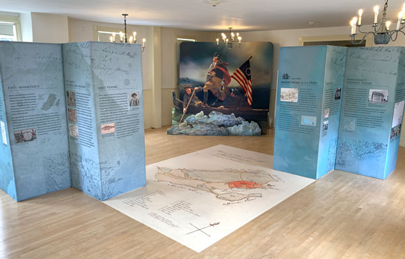 The second exhibit, Mapping Marblehead, the Nineteenth Century focused on the transformation of Marblehead from a fishing village to an industrial center for shoemaking and then to a center for yachting and tourism. The third exhibit, Mapping Marblehead the 20th century and beyond focused on the tremendous growth and development of Marblehead throughout the 20th century and into the 21st. The Commission is working on a permanent museum of Marblehead’s history.
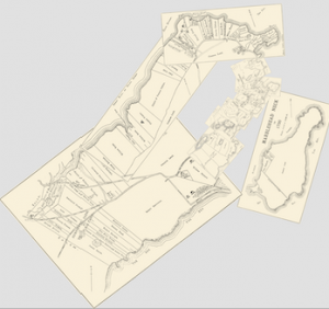
Maps were central to all three Mapping Marblehead exhibits and many of the videos and interactive map exhibits are now available via a web browser. Through maps, the changes in the town are clearly visible, and studying them can reveal those changes in dramatic, and often surprising, ways. Videos offer guidance on some interesting map features, and interactive maps let visitors compare present day Marblehead with maps of its earlier times. For map lovers and researchers, a list of maps relevant to Marblehead’s history, along with links to their web locations, is also provided.
To review the history of the exhibits, download the exhibit booklets as PDF files here:
Mapping Marblehead from Founding to Freedom exhibit booklet (12 MB PDF file)
Mapping Marblehead the 19th Century exhibit booklet (7 MB PDF file)
Mapping Marblehead the 20th century and beyond exhibit booklet (7 MB PDF file)
Mapping Marblehead – the Videos
Follow these links to introductory videos and a “how to use” video on the Marblehead Historical Commission YouTube Channel.
Introduction to Mapping Marblehead – from Founding to Freedom
(This link takes you to a video on the Commission’s YouTube channel)
 Introduction to Mapping Marblehead, the Nineteenth Century
(This link takes you to a video on the Commission’s YouTube channel)
 Growth and Development Animation
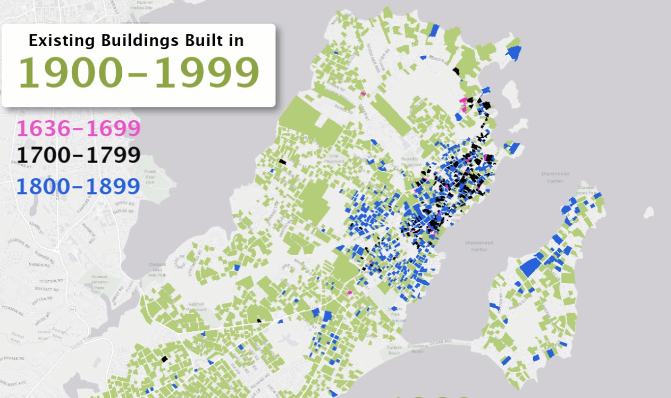
This animation shows the growth of Marblehead from the earliest recorded building date in 1636 to 2017. Buildings are shown cumulatively, with the year indicator showing the year that is being added to the map. Each century’s buildings are color-coded as shown in the legend. Only buildings that still exist are shown. Map data provided by MassGIS, Standardized Assessors’ Parcels.
Mapping Marblehead – the Interactive Maps
To view and interact with a map, open it in your browser by clicking the link. Each map opens with a vertical line and a drag handle in the middle that allows you to swipe horizontally to compare the historical map with a current map of Marblehead. You can turn the swipe handle off to see the entire historical map. Use the + and – buttons to zoom in and out on the map. For maps with markers or map pins, click on the icon to learn more. For maps with more than one layer, use the layers button to select the layers that are visible. The Base Map button allows you to change the underlying map to one of your choosing. The information button provides a description of the map and a reminder of how to use it.
Mapping Marblehead, from Founding to Freedom (the 17th and 18th centuries)
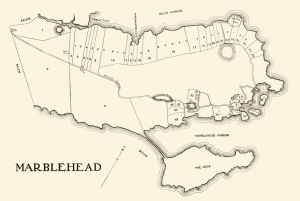
The first exhibit featured four maps of early Marblehead that show where indigenous people made the area their home, how Marblehead looked in 1649, how it looked in 1700, and the first town plan of 1795.
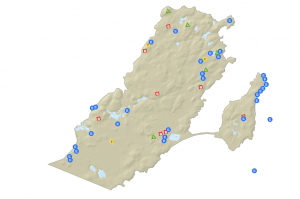
Native American Sites
This interactive map allows comparison of Don Doliber’s map of native American sites in Marblehead with a current map. The earliest inhabitants of were the Naumkeags, a part of the nomadic Algonquin nation of woodland tribes, who came to Marblehead for the same reason that people come today: to live by the sea shore in a relaxed and healthful way. They came to fish, clam, and collect shells. They also collected salt from the ocean to use in seasoning and preserving their food. This map was compiled by Donald Doliber, Town Historian, Town of Marblehead.
Marblehead in 1649
This interactive map allows comparison of Sidney Perley’s map of Marblehead in 1649 with a current map. This map was hand drawn in 1926 from historical records and published in Perley’s History of Salem.
Marblehead in 1700
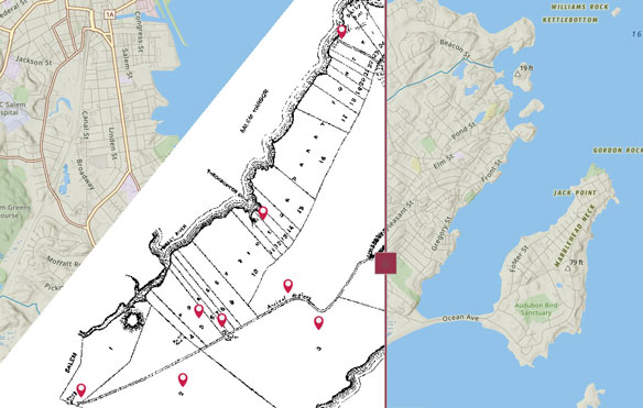
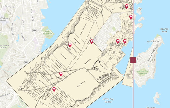
This interactive map allows comparison of Sidney Perley’s map of Marblehead in 1700 with a current map. Using historical records, Sidney Perley created 10 maps of the sections of Marblehead that are shown here as a single map overlay on a current map of Marblehead. The original, individual maps were not drawn to the same scale, so the thickness of the lines varies greatly between the digitized maps. In addition, the overlapping areas often changed between maps. Perley did not create a single map with all of Marblehead in 1700, but modern mapping technology allowed the creation of such a map. The composite map was created from a series maps published in three volumes of the Historical Collections of the Essex Institute, Volumes 46-48, published in 1910-12, Salem, MA.
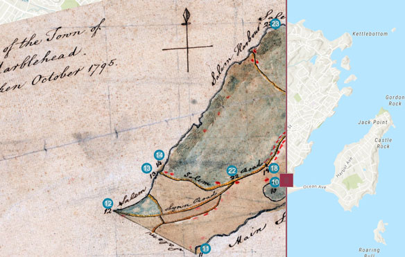
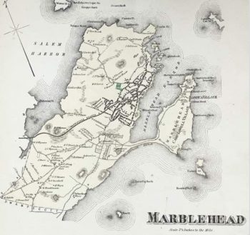
Marblehead Town Plan of 1795
This interactive map allows comparison of Alfred Ingall’s map of Marblehead in 1795 with a current map. In 1795, the newly formed state of Massachusetts commissioned a survey of all of the towns within the state. This map, hand-drawn by Alfred Ingalls in 1795, is part of that series of town plans of the newly formed United States. It shows the built up areas (in red), roads, and other highlights, each one carefully numbered and described in the key. Marblehead was a thriving town and the built-up areas encompassed both the original Little Harbor area and much of the main harbor.
Mapping Marblehead, the Nineteenth Century
Two interactive maps from the 19th century show a town that has grown substantially, but one that is still evolving.
 1850 McIntyre Plan of Marblehead
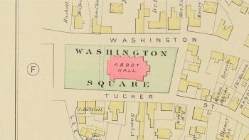
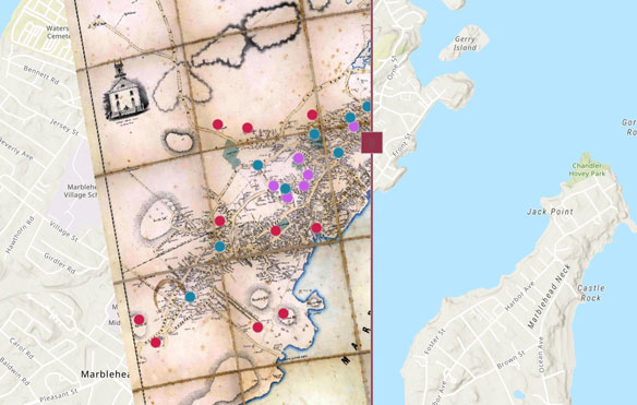
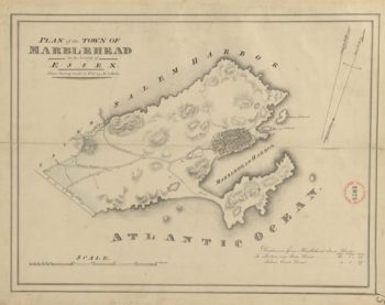
This interactive map of Marblehead by Henry McIntyre from 1850 allows comparison with a current map. It highlights the churches, schools, and other points of interest. By 1850 Marblehead had grown in both size and density. Mapping techniques had also evolved to create more accurate maps from “actual survey” as this map by Henry McIntyre proudly proclaims. Vignettes of buildings around the top of the map show buildings as they appeared in mid-century. Abbot Hall had not yet been built, nor were shoe factories in evidence. Ropewalks and shipyards made it clear that fishing was still the industry at the time. Religion and education were both very important to the town’s population as indicated by the number of churches and schools.
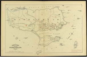
 1872 Beers Atlas of Essex County
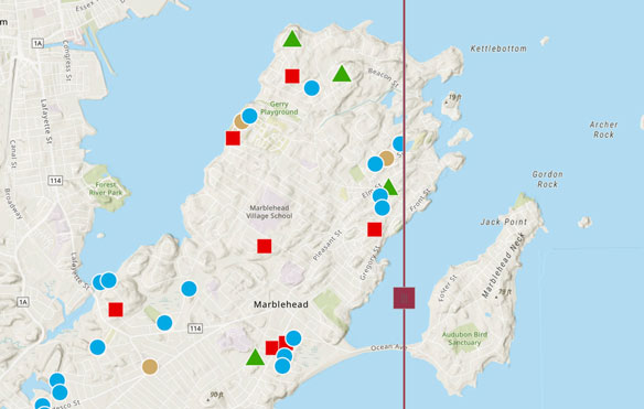
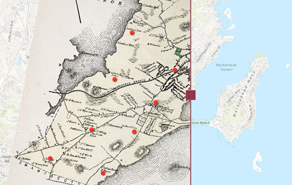
This interactive map of Marblehead by D.G. Beers & Co. from 1872 allows comparison with a current map. This map of Marblehead is from an untitled atlas of Essex County, published by D.G. Beers in 1872. The downtown area continues to be built out and there is expansion both inland and to the south. During this time, the population grew from a little over 5,000 in 1830 to nearly 8,000 at the time of this map. The Neck is still relatively undeveloped and is mostly a tenting spot known as “Camp Lowell Village.” The Swampscott branch of the railroad was not yet built, Points of interest are indicated by red dots. Tap or click on them for more information.
Mapping Marblehead, the 20th century and beyond
 Marblehead in 1954
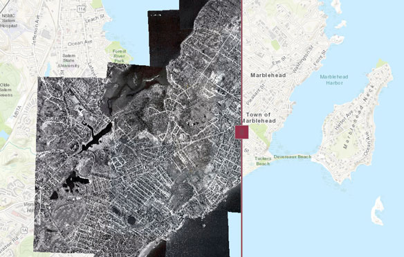
Imagery from 1954 has been georeferenced and combined to created a view of Marblehead at that time. This interactive map of Marblehead aerial imagery from 1954 allows comparison with a current map, but the Base Map can be changed so imagery from 1954 can be overlaid on today’s imagery.
Mapping Marblehead – the Historical Maps
The following links will help you find high-resolution digitized versions of the maps featured in Mapping Marblehead as well as their accompanying historical documents.
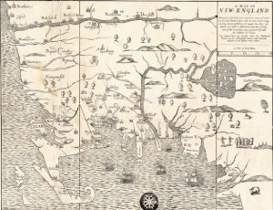
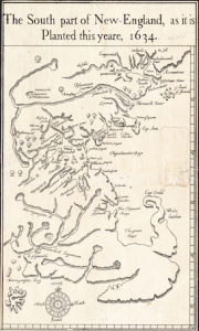 South part of New-England, as it is planted this yeare, 1634 by William Wood
This map was published in William Wood’s New Englands Prospect in London to encourage settlement in the colonies. Marble Harbor is shown of the map, but the text of New Englands Prospect refers to Marvill Head. (Map reproduction courtesy of the Norman B. Leventhal Map & Education Center at the Boston Public Library.)
 Map of New England…1677 by John Foster
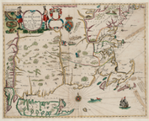
This map was among the first maps printed in America and was used to illustrate The present state of New England : being a narrative of the troubles with the Indians, 1677 by William Hubbard. Marblehead is shown with its modern spelling on this map. (Map reproduction courtesy of the Norman B. Leventhal Map & Education Center at the Boston Public Library.)
 Map of New England – based on his voyage of 1614
John Smith
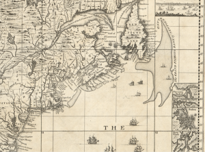
1775 An actual survey of the sea coast from New York to the I. Cape Briton, with tables of the direct and thwart courses & distances from place to place.(Detail of inset map), Cyprian Southack, 1775
This map encompasses much of the eastern sea coast, but the inset map clearly shows the distance from Marblehead to the Grand Banks fishing grounds. (Map courtesy of the Library of Congress, Geography and Map Division.)
 1675 A Mapp of New England by John Seller
Marblehead is shown as “Marblehed” on this map. (Map reproduction courtesy of the Norman B. Leventhal Map & Education Center at the Boston Public Library.)
 Marblehead in 1649 from The History of Salem by Sidney Perley, 1926
In 1926, Perley published a history of Salem that included this map of Marblehead, drawn from legal records and deeds. This map can be found in Volume 2, Chapter 13, p. 197.
Explore this map: Mapping Marblehead – Interactive Exploration
 Marblehead in the year 1700 by Sidney Perley, 1910-1912
Sidney Perley’s maps of Marblehead in the year 1700 (and accompanying history) were published in nine articles from three volumes of the Historical Collections of the Essex Institute, Volumes 46-48, published in 1910-1912, Salem, MA. Article titles: “Marblehead in the year 1700”. Digital copies: Volume 46 Volume 47 Volume 48
Explore this map: Mapping Marblehead – Interactive Exploration
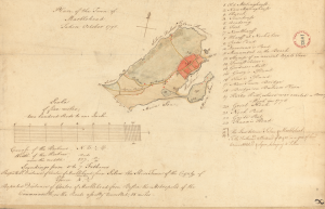 Plan of the Town of Marblehead by Alfred Ingalls, 1795
Commissioned by the state of Massachusetts as part of a survey of all of the state’s towns, it was drawn by Alfred Ingalls in 1795. This map of Marblehead is the first known map of the Town and is in the collection of the Massachusetts State Archive.
Explore this map: Mapping Marblehead – Interactive Exploration
 Marblehead Growth 1636 to 2017
This one minute video (on the Commission’s YouTube channel) shows the growth of Marblehead, Massachusetts from the earliest recorded building in 1636 to 2017. Buildings are shown cumulatively, with the year indicator showing the year that is being added to the map. Each century’s buildings are color-coded as shown in the legend. Map created by David Krathwohl with data from MassGIS property assessment records. It shows houses and buildings that still exist, but houses that were torn down and replaced are not included in the data.
Explore this map: Mapping Marblehead – Interactive Exploration
 1830 Plan of Marblehead made by John G. Hales, dated 1830
A follow on to the Plan of the Town of Marblehead by Alfred Ingalls in 1795, this map was required by the state, with specifications for the scale and features to be shown.
 1850 Plan of Marblehead by Henry McIntyre
This is one of the first maps of Marblehead to use modern surveying techniques. It is also the earliest detailed map of the town, often including the names of property owners and the locations of important commercial buildings. This version of the map was cut and mounted on linen so it could be folded. The digital copy of the map was created from scans of each square made by Standley Goodwin from two copies of the map by selecting the most legible sections from each copy. The merged version of these scans was created by David Krathwohl. Standley has also created a complete version of the map that includes content that was lost in the cuts. A complete scan of another copy of the map is provided by the Levanthal map library, but unfortunately the resolution makes it difficult to read some of the smaller names.
1850 McIntyre Plan of Marblehead from the Mapping Marblehead exhibit – 4 MB PDF
Link to 1850 McIntyre Plan of Marblehead on the Levanthal Map Library website, Boston Public Library
 1872 D.G. Beers & Co. from an untitled atlas of Essex County
https://digitalcommons.salemstate.edu/maps_essexcounty/40/
 1881 Atlas of Marblehead, Mass. by Griffith Morgan Hopkins, Jr.
Follow this link to download a pdf of the 1881 atlas that was reproduced in print form for the Mapping Marblehead, the Nineteenth Century exhibit.
https://archives.lib.state.ma.us/handle/2452/206046
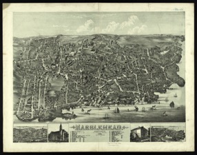 1882 Marblehead, Massachusetts by Bailey, O. H. Bailey
This fascinating birds eye view of Marblehead rewards hours of exploration. Follow this link to download a digital copy courtesy of the Boston Public Library’s Norman B. Leventhal Map Center.
https://ark.digitalcommonwealth.org/ark:/50959/x633f963f
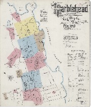 1890 Sanborn Fire Insurance Map from Marblehead, Essex County, Massachusetts, by the Sanborn Map Company
The Sanborn Map company created a series of maps for the fire insurance industry. These maps preserve an incredible level of detail that includes building materials, flammable materials, and information about watchmen. The Library of Congress has digitized many of the Sanborn maps and makes them available through their website.
https://www.loc.gov/item/sanborn03777_002/
 1909 Birdseye View of Marblehead by A.E. Downs
Published by Merrill H. Graves in Marblehead, this birdseye view is a great snapshot of Marblehead in the first decade of the 20th century. A numbered key helps to locate historic town buildings and landmarks, schools, churches, hotels, and yacht clubs. Though the building density of the downtown area had increased dramatically, there are still large areas of farmland on the Salem Harbor side of the Town, and the Neck was still relatively undeveloped. (Marblehead Historical Commission collection)
View the 1909 Downs Birdseye View of Marblehead (6 MB file)
 1912 Atlas of the Town of Marblehead published by Walker Lithography and Publishing Company
The Atlas of the Town of Marblehead was published in 1912 by the Walker Lithography and Publishing Company in Boston. It is a comprehensive atlas of Marblehead that includes all areas of the town in 14 double page plates. It includes buildings that are color coded by building material, addresses and owners of properties, municipal buildings, churches, schools, electric railways, and fire hydrants.
For a PDF of the atlas (19 MB file) see State Library of Massachusetts:
https://archives.lib.state.ma.us/handle/2452/206048

